Monitoring Overview
Monitoring water levels during floods can help us to assess the timing of a flood and how serious the local impacts might be. SOFLAG is working towards developing a local monitoring network, and providing guidance on how to interpret information that comes from it. We will also include information from the existing Environment Agency river station network.
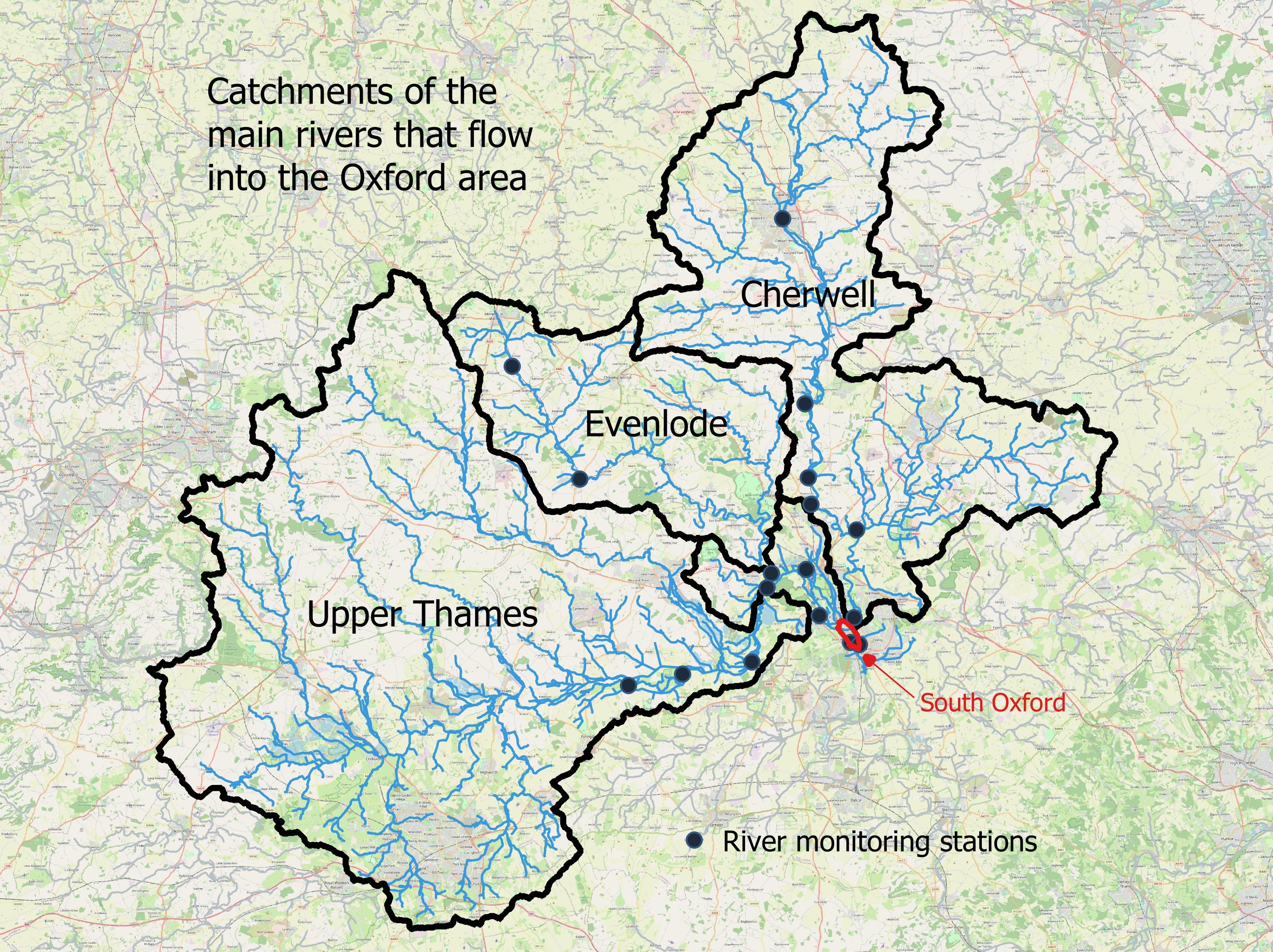
Flooding in South Oxford is complex - flood waters come from the Hinksey Stream in the west, the River Thames and the Weirs Mill Stream in the east, and upwards as groundwater from the gravels beneath. The number of rivers that join to flow past South Oxford adds complexity: the River Thames has a large catchment including the Cotswold Hills; the River Evenlode joins the Thames from the north just above Oxford; and the River Cherwell joins the Thames from the east, just downstream of the city centre.
The rivers respond to rainfall in the three catchments differently. As is often the case, rainfall can be much greater in one catchment than the others. This means that flood events in South Oxford can be quite different from one another, both in the timing and the direction that the flood waters come from.
The Environment Agency (EA) collects lots of data on the rainfall and river levels upstream of Oxford. They use this, along with rainfall forecasts and computer models, to predict where and when flooding will occur. They provide Flood Alerts when flooding appears likely and Flood Warnings when it is imminent, and send these directly to residents who have signed up to their service. If you haven’t already, you can sign up to the service here.
Lots of the information that the EA uses is available to the general public, and SOFLAG can use it to gain a more detailed understanding of when a flood will happen in South Oxford and, importantly, when the water will start to disappear after the flood. Live river levels can be viewed on the Government’s ‘Check for flooding’ web site. Each river level measuring station can be accessed from a map of the river system.
The Government site also provides up-to-date rainfall measurements. However, experience tells us that there is not a specific rainfall amount upstream that will definitely result in flooding in South Oxford – past floods have happened after a couple of days of severe rainfall, or 5-10 days of smaller amounts of rainfall when the river levels are already high. Floods in the past 25 years have resulted from total rainfall over a number of days in a wide range - from as little as 25 mm up to 120 mm. Therefore, it is very difficult to predict when or how a flood will happen in the area.
Nevertheless, looking at river levels upstream of South Oxford gives us some insight on an imminent flood. Water levels in and around South Oxford helps to see what the local impacts are. Here, in the future, we aim to provide information and guidance on how to interpret this information - both for the upstream and local status of flood events.